for Friday, 26 March 2010 [6:37 PM PhT]


<<<Typhoon2000.com Mobile >>>
Get the latest 6-Hrly SMS Storm Alerts on AGATON!
For more details: Text T2K TYPHOON to
2800 (Globe/TM) | 216 (Smart/TNT) | 2288 (Sun)
*only P2.50 (Smart/Globe) / P2.00 (Sun) per msg received.
powered by: Synermaxx
Typhoon2000 (T2K) NEWS (Fri March 26 2010):
Ending the 6-hrly advisories (except 12 AM PhT) on TS OMAIS (AGATON).
OMAIS (AGATON) MAX WIND SPEED PER AGENCY:
+ USA (JTWC/1-min avg): 65 km/hr
+ Japan (JMA/10-min avg): 45 km/hr
+ Philippines (PAGASA/10-min avg): 55 km/hr
+ Korea (KMA/10-min avg): 65 km/hr
+ Hong Kong (HKO/10-min avg): 65 km/hr
+ Taiwan (CWB/10-min avg): 65 km/hr
+ Beijing (NMC/2-min avg): 65 kph
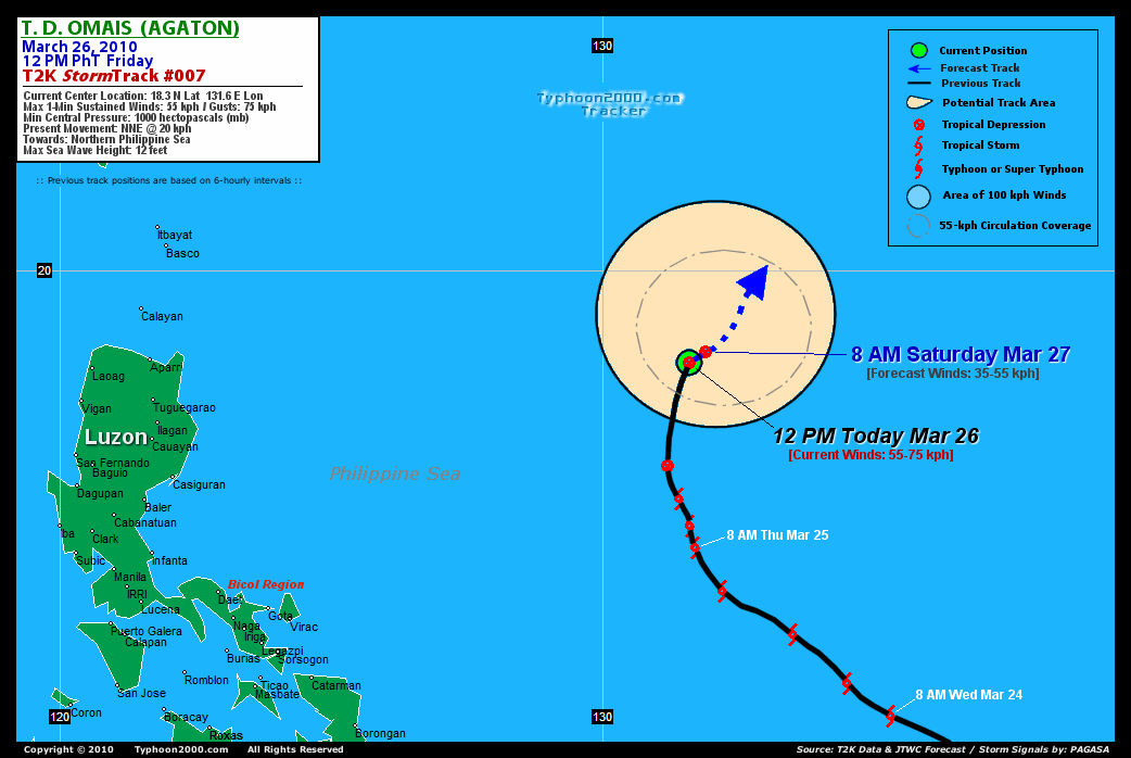
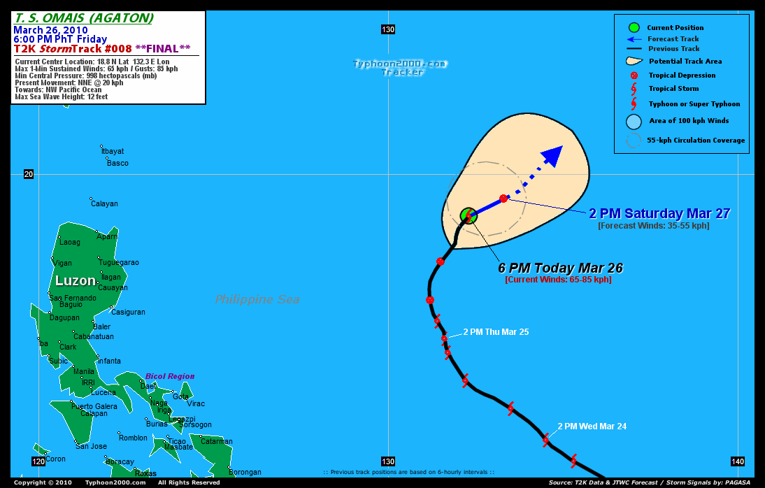
TROPICAL STORM OMAIS [AGATON/02W/1001]
T2K E-MAIL ADVISORY NUMBER 014 (FINAL)
6:00 PM PhT (10:00 GMT) Fri 26 March 2010
Source: T2K Analysis/JTWC Warning #019 (Final)
View: Advisory Archives (2004-2010)
OMAIS (AGATON) regains Tropical Storm strength but is losing tropical characteristics...becoming Extratropical as it merges with a passing Frontal System south of Japan.
*This is the Final Advisory on the Philippines' first tropical cyclone of 2010.
*Do not use this for life or death decision. This advisory is intended for additional information purposes only. Kindly refer to your country's official weather agency for local warnings, advisories & bulletins.
Current Storm Information
Time/Date: 6:00 PM PhT Fri Mar 26 2010
Location of Center: 18.8º N Lat 132.3º E Lon
Distance 1: 965 km (520 nm) SSE of Okinawa, Japan
Distance 2: 1,095 km (590 nm) ESE of Basco, Batanes
Distance 3: 1,120 km (605 nm) ENE of Aparri, Cagayan
Distance 4: 1,145 km (618 nm) SW of Iwo To
Distance 5: 1,290 km (697 nm) NE of Metro Manila
MaxWinds (1-min avg): 65 kph (30 kts) near the center
Peak Wind Gusts: 85 kph (40 kts)
6-hr Rain Amounts (near the center): 220 mm [Heavy]
Minimum Central Pressure: 998 millibars (hPa)
Saffir-Simpson Typhoon Scale: TS
Present Movement: NNE @ 20 kph (11 kts)
Towards: Central Philippine Sea
Size (in Diameter): 295 km (160 nm) / Small
Max Sea Wave Height (near center): 12 ft (3.6 m)
Coastal Storm Surge Height: 0 feet [0 m]
T2K Final TrackMap #008 (for Public): 6 PM PhT Fri Mar 26
+ Forecast Outlook: OMAIS (AGATON) is expected to complete Extratropical transition w/in the next 12 to 24 hours [2PM MAR 27: 19.3N 133.3E...1,190 km ESE of Basco, Batanes].
+ Effects & Hazards: OMAIS' decaying rainbands remain over the sea...no effects & hazards are in place. 6-hr total rainfall amounts of 5 up to 100 mm (light to moderate rain) can be expected along the its rainbands...with isolated amounts of up to 220 mm (heavy rain) situated along the northeastern periphery of OMAIS' (AGATON) center. Click here to view the latest NOAA's eTRaP graphic on the storm's rainfall amount.
+ Current NE Monsoon Intensity: MODERATE >> Partly Sunny to mostly cloudy skies with occasional drizzles-showers-rains can be expected along the following affected areas: BATANES GROUP, CAGAYAN, ISABELA, AURORA, QUEZON, BICOL REGION & NORTHERN SAMAR. Light to moderate NE winds (not in excess of 45 kph) can be expected along these areas. Large ocean waves of 10 to 12 feet along the beach-front areas of the affected areas are likely to occur beginning today until Monday.
[Important Note: Please keep in mind that the above forecast outlook, effects, current monsoon intensity, & tropical cyclone watch changes every 6 to 12 hrs!]
External Links for TS OMAIS (AGATON)
View NOAA-CIRA's Latest Wind Analysis
JTWC Final Tracking Chart: wp0210.gif
Multi-Agency Forecast TrackMap: 2 PM Fri Mar 26
TSR Wind Probabilities: Current to 24 hrs Ahead
Zoomed Satellite Pic: NOAA's Near Real-Time
Wunderground Animation: 6-12 hr. GIF Loop
JTWC (US NAVY / AIR FORCE) 12 & 24 HR. FORECAST & REMARKS:
2 AM (18 GMT) 27 MARCH: 18.8N 132.6E / 45-65 KPH (XT) / NE @ 07 KPH
2 PM (06 GMT) 27 MARCH: 19.3N 133.3E / 35-55 KPH (XT)
<<<Typhoon2000.
Get the latest 6-Hrly SMS Storm Alerts on AGATON!
For more details: Text T2K TYPHOON to
2800 (Globe/TM) | 216 (Smart/TNT) | 2288 (Sun)
*only P2.50 (Smart/Globe) / P2.00 (Sun) per msg received.
powered by: Synermaxx
Typhoon2000 (T2K) NEWS (Fri March 26 2010):
Ending the 6-hrly advisories (except 12 AM PhT) on TS OMAIS (AGATON).
OMAIS (AGATON) MAX WIND SPEED PER AGENCY:
+ USA (JTWC/1-min avg): 65 km/hr
+ Japan (JMA/10-min avg): 45 km/hr
+ Philippines (PAGASA/10-min avg): 55 km/hr
+ Korea (KMA/10-min avg): 65 km/hr
+ Hong Kong (HKO/10-min avg): 65 km/hr
+ Taiwan (CWB/10-min avg): 65 km/hr
+ Beijing (NMC/2-min avg): 65 kph
TROPICAL STORM OMAIS [AGATON/02W/
T2K E-MAIL ADVISORY NUMBER 014 (FINAL)
6:00 PM PhT (10:00 GMT) Fri 26 March 2010
Source: T2K Analysis/JTWC Warning #019 (Final)
View: Advisory Archives (2004-2010)
*This is the Final Advisory on the Philippines' first tropical cyclone of 2010.
*Do not use this for life or death decision. This advisory is intended for additional information purposes only. Kindly refer to your country's official weather agency for local warnings, advisories & bulletins.
Current Storm Information
Time/Date: 6:00 PM PhT Fri Mar 26 2010
Location of Center: 18.8º N Lat 132.3º E Lon
Distance 1: 965 km (520 nm) SSE of Okinawa, Japan
Distance 2: 1,095 km (590 nm) ESE of Basco, Batanes
Distance 3: 1,120 km (605 nm) ENE of Aparri, Cagayan
Distance 4: 1,145 km (618 nm) SW of Iwo To
Distance 5: 1,290 km (697 nm) NE of Metro Manila
MaxWinds (1-min avg): 65 kph (30 kts) near the center
Peak Wind Gusts: 85 kph (40 kts)
6-hr Rain Amounts (near the center): 220 mm [Heavy]
Minimum Central Pressure: 998 millibars (hPa)
Saffir-Simpson Typhoon Scale: TS
Present Movement: NNE @ 20 kph (11 kts)
Towards: Central Philippine Sea
Size (in Diameter): 295 km (160 nm) / Small
Max Sea Wave Height (near center): 12 ft (3.6 m)
Coastal Storm Surge Height: 0 feet [0 m]
T2K Final TrackMap #008 (for Public): 6 PM PhT Fri Mar 26
+ Forecast Outlook: OMAIS (AGATON) is expected to complete Extratropical transition w/in the next 12 to 24 hours [2PM MAR 27: 19.3N 133.3E...1,190 km ESE of Basco, Batanes].
+ Effects & Hazards: OMAIS' decaying rainbands remain over the sea...no effects & hazards are in place. 6-hr total rainfall amounts of 5 up to 100 mm (light to moderate rain) can be expected along the its rainbands...
[Important Note: Please keep in mind that the above forecast outlook, effects, current monsoon intensity, & tropical cyclone watch changes every 6 to 12 hrs!]
External Links for TS OMAIS (AGATON)
View NOAA-CIRA's Latest Wind Analysis
JTWC Final Tracking Chart: wp0210.gif
Multi-Agency Forecast TrackMap: 2 PM Fri Mar 26
TSR Wind Probabilities: Current to 24 hrs Ahead
Zoomed Satellite Pic: NOAA's Near Real-Time
Wunderground Animation: 6-12 hr. GIF Loop
2 AM (18 GMT) 27 MARCH: 18.8N 132.6E / 45-65 KPH (XT) / NE @ 07 KPH
2 PM (06 GMT) 27 MARCH: 19.3N 133.3E / 35-55 KPH (XT)
REMARKS (for Meteorologists)
*THE SYSTEM IS CURRENTLY INTERACTING WITH A
BAROCLINIC BOUNDARY AND IS RAPIDLY LOSING ITS TROPICAL
CHARACTERISTICS. ENHANCED POLEWARD OUTFLOW AHEAD OF THE SUPPORTING
UPPER LEVEL TROUGH HAS HELPED SUSTAIN DEEP, ALBEIT SHEARED
CONVECTION. VERTICAL WIND SHEAR HAS ELEVATED TO NEAR 40 KNOTS
ACCORDING TO THE LATEST CIMMS ANALYSIS. DVORAK ESTIMATES RANGE FROM
30 TO 35 KNOTS FROM PGTW AND RJTD, THROUGH PGTW IS NO LONGER
CLASSIFYING THE SYSTEM AS TROPICAL. AMSU TEMPERATURE CROSS SECTIONS
FROM 252000Z INDICATE THAT THE WARM CORE IS SHEARED SEVERAL DEGREES
FROM THE LOW LEVEL CIRCULATION CENTER (LLCC), AND A COOLER
TEMPERATURE ANOMALY HAS BEGUN TO DEVELOP OVER THE LLCC. THE INITIAL
POSITION IS CONSISTENT WITH A 260429 AMSU-B MICROWAVE IMAGE, WHICH
SHOWS THE LLCC LAGGING BEHIND THE SHEARED CONVECTION TO THE
SOUTHWEST. THE LLCC IS FORECAST TO TRACK ALONG THE BAROCLINIC
BOUNDARY TOWARDS THE NORTHEAST AND WILL INCORPORATE INTO THE
BOUNDARY WITHIN THE NEXT 12 TO 24 HOURS BECOMING FULLY
EXTRATROPICAL. THIS IS A CHANGE IN PHILOSOPHY FROM THE PREVIOUS
FORECAST, WHICH HAD CALLED FOR DISSIPATION. THIS IS THE FINAL
WARNING ON THIS SYSTEM BY THE JOINT TYPHOON WARNING CENTER
(NAVMARFCSTCEN)
REGENERATION.
>> OMAIS, meaning: Palauan word for "wandering around". Name contributed by: United States of America.
____________
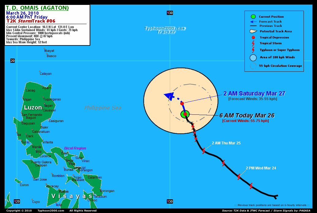
PAGASA CURRENT POSITION, MOVEMENT AND INTENSITY (10-min. ave.):
> 2 PM (06 GMT) FRI 26 MARCH: 18.3N 132.3E / NE @ 17 kph / 55 kph
:: For the complete PAGASA bulletin, kindly visit their website at:
http://www.pagasa.dost.gov.ph/wb/tcupdate.shtml
_______________________________________________________________________________________________________________________________________
:: For the complete PAGASA bulletin, kindly visit their website at:
http://www.pagasa.
____________
RECENT TYPHOON2000.
________________________
RECENT MTSAT-1R "DAY & NIGHT VISION" SATELLITE IMAGE:

> Image source: NOAA SATELLITE CENTER
RECENT WUNDERGROUND SATELLITE ANIMATION:

> Image source: Wunderground.com (http://www.wunderground.com/ ) ____________________________________________________________________________________________________________________
> Image source: NOAA SATELLITE CENTER
____________________________________________________________________________________________________________________
RECENT WUNDERGROUND SATELLITE ANIMATION:
> Image source: Wunderground.
LATEST 6 HR. TOTAL RAINFALL AMOUNTS / ENSEMBLE TROPICAL RAINFALL POTENTIAL (eTRaP):

> Image source: NOAA Satellite & Information Service (http://www.ssd.noaa.gov/PS/TROP/etrap.html )____________________________________________________________________________________________________________________
> Image source: NOAA Satellite & Information Service (http://www.ssd.
NOTE:
* - JTWC commentary remarks (for Meteorologists) from their latest warning.
__________________________________________________________________________________________
>> To know the meteorological terminologies and acronyms used on this update visit the ff:
http://typhoon2000.ph/tcterm.htm
http://www.nhc.noaa.gov/aboutgloss.shtml
http://www.srh.noaa.gov/oun/severewx/glossary.php
http://www.srh.weather.gov/fwd/glossarynation.html
http://www.nhc.noaa.gov/acronyms.shtml
__________________________________________________________________________________________
For the complete details on TS OMAIS (AGATON)...go visit our website @:
> http://www.typhoon2000.com
> http://www.maybagyo.com
>> To know the meteorological terminologies and acronyms used on this update visit the ff:
http://typhoon2000.
http://www.nhc.
http://www.srh.
http://www.srh.
http://www.nhc.
____________
> http://www.typhoon2
> http://www.maybagyo
Copyright © 2010 Typhoon2000.
__._,_.___
.
__,_._,___